
Cleveland when we left.
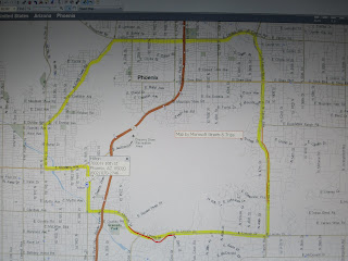
Arrived at my hotel around 12:30 and started a skate around Squaw Peak at 1:30. The yellow highlight shows the route. There are many sections of sidewalk with gravel and stones. On E Cactus Rd I got a little too confident going through a gravely area and took a minor spill. Somehow I managed to dump my latte on the ground just ahead of placing my butt there. Other than a wet rear end I was fine. The orange area was an area of very rough pebbly paved sidewalk. I almost took my skates off to walk it but I kept on going assuming it would get better over the next rise. The red area is an area of no sidewalks and unskatable rd. I walked that section.
The route goes through mostly nice neighborhoods with lots of places to stop for food and drinks. The entire skate is on sidewalks with only one section of brick sidewalk along North Cave Creek Rd
The mountains are mostly surrounded by developed areas. So, access to climbing them is very limited. There were sections along Cave Creek Rd with direct access to the mountains with no fences, signs, or homes. I didn’t take advantage because I knew I had to finish the route before dark. The intersection of N 32nd St and E Lincoln there is access to a very interesting part of the mountains. There is also a shopping center nearby so it would be possible to get there by car.
Here is a link to see the area in Bing http://www.bing.com/maps/explore/#5003/o=&a=&s=w/5872/style=be&lat=pkv2d7&lon=5nypmg&alt=418.439301&z=13&pid=5874
The route was almost 20 miles. That and a few rough stretches wore me out. Back at the hotel I discovered a hot tub attached to the pool. Very relaxing.

The mountains come right down to the sidewalk in some places. I had the chance to climb up this hill.
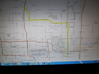
I studied maps and decided to take the all purpose trail along the Arizona canal to Scottsdale. Well, the trail turned to gravel at N 24th St. So I took N 24th St south to W Camelback Rd and took that east to Scottsdale. N 24th and W Camelback is a very fancy large shopping area. This intersection and Scottsdale would both be good places to skate for a few hours. They would also be good places to find a pair of pre worn out $200 blue jeans.
From Scottsdale I took N Scottsdale Rd south to Tempe. Tempe is a college town just south of the Salt River. There is a dam just downstream of Tempe so this part of the Salt River actually has water in it.

The Arizona Canal has Paved trails along side from N 24th St. I don’t know how far it has paved trails to the north west. In this photo to the right you can see the top of the big ditch.
This 20 to 30 foot deep ditch runs next to canal for miles. It must be for flood water. It seem strange to see a water way so close to a ditch that is way below the water level of the water way. In this area the Arizona Canal is on the high ground so it seems like a viaduct.
Trip ideas:
Park in the shopping center at N 32nd and W Camelback, and hike up the mountain.
Spend a half a day skating the Scottsdale area.
Follow the Salt River around Phoenix as far as possible.
Spend half a day skating Tempe.
See how far the Arizona canal goes northwest.
The route goes through mostly nice neighborhoods with lots of places to stop for food and drinks. The entire skate is on sidewalks with only one section of brick sidewalk along North Cave Creek Rd
The mountains are mostly surrounded by developed areas. So, access to climbing them is very limited. There were sections along Cave Creek Rd with direct access to the mountains with no fences, signs, or homes. I didn’t take advantage because I knew I had to finish the route before dark. The intersection of N 32nd St and E Lincoln there is access to a very interesting part of the mountains. There is also a shopping center nearby so it would be possible to get there by car.
Here is a link to see the area in Bing http://www.bing.com/maps/explore/#5003/o=&a=&s=w/5872/style=be&lat=pkv2d7&lon=5nypmg&alt=418.439301&z=13&pid=5874
The route was almost 20 miles. That and a few rough stretches wore me out. Back at the hotel I discovered a hot tub attached to the pool. Very relaxing.

The mountains come right down to the sidewalk in some places. I had the chance to climb up this hill.

I studied maps and decided to take the all purpose trail along the Arizona canal to Scottsdale. Well, the trail turned to gravel at N 24th St. So I took N 24th St south to W Camelback Rd and took that east to Scottsdale. N 24th and W Camelback is a very fancy large shopping area. This intersection and Scottsdale would both be good places to skate for a few hours. They would also be good places to find a pair of pre worn out $200 blue jeans.
From Scottsdale I took N Scottsdale Rd south to Tempe. Tempe is a college town just south of the Salt River. There is a dam just downstream of Tempe so this part of the Salt River actually has water in it.

The Arizona Canal has Paved trails along side from N 24th St. I don’t know how far it has paved trails to the north west. In this photo to the right you can see the top of the big ditch.

This 20 to 30 foot deep ditch runs next to canal for miles. It must be for flood water. It seem strange to see a water way so close to a ditch that is way below the water level of the water way. In this area the Arizona Canal is on the high ground so it seems like a viaduct.
Trip ideas:
Park in the shopping center at N 32nd and W Camelback, and hike up the mountain.
Spend a half a day skating the Scottsdale area.
Follow the Salt River around Phoenix as far as possible.
Spend half a day skating Tempe.
See how far the Arizona canal goes northwest.