Date: 9/24/10
Location: Cleveland
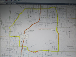
Miles: About 12
Interactive Map link: http://maps.google.com/maps/ms?msa=0&msid=205179460621910658689.00047e2d503e0d085caef For some reason this map shows the entire country. To see the skate route you have to zoom in on Cleveland.
YouTube link: http://www.youtube.com/profile?user=buschmantom#p/u/0/Cg5RvLolMzU
This was a relatively short skate with lots to see. The basic route was East 55th St, to Euclid Ave to Martin Luther King Drive, then I followed the lake front parks north back to East 55th St.
The skate includes passing three major medical centers. Skating around these large medical centers makes it obvious why Cleveland is world famous for it’s medical research and care.

Cleveland clinic:
The Cleveland Clinic is regarded as one of the top 4 hospitals in the United States and ranked number one in cardiac care for 15 years in a row. Cleveland Clinic's annual research expenditures exceed $258,000,000. The Clinic has approximately 1700 salaried staff physicians. Half the skate along Euclid Ave is spent going past the buildings of the Cleveland Clinic

Severance Hall, home of the Cleveland Orchestra since 1931

1032 beds, 24,000 physicians and employees make it the second largest private sector employer in Ohio. Wall Mart is the biggest with 53,000 employees in Ohio. Rainbow Babies and Children’s Hospital, Ireland Cancer Center, and MacDonald Women’s Hospital are all part of University Hospital System

Case Western Reserve University sits on a 155 acre campus. It is a research oriented college with 10,000 students and an annual operating budget of $897,000,000. In 2010 Case was rated as the best college in Ohio by US News. According to the Case web site it awarded 2,673 degrees in 2008-09 session and had 2,745 full time faculty. That’s one faculty per student graduated. If the average student is there for 4 years that would be 4 students to 1 faculty ratio.


The Cleveland Museum of Art opened in 1916 and was built at a cost of $1.25 million dollars. I don’t think you could build the back stairs that go down to the Wade Lagoon for that amount of money now. From their web site “We are proud to be one of the world’s most distinguished comprehensive art museums and one of northeastern Ohio’s principal civic and cultural institutions.” The museum has 43,000 works of art. From Wikipedia “The museum is internationally renowned for its substantial holding of Asian and Egyptian art.” General admission is free.

From thier web site. “The Louis Stokes Cleveland VA Medical Center is the 5th largest VA in the country serving almost 95,000 Veterans each year.” There are 153 VA hospitals across the country with a total of 304,099 employees. The Cleveland VA Medical Center is currently involved in a massive construction project.


Church of the Holy Oil Can